The Landscape Decision Support System (DSS) is a prototype knowledge and evaluation system that, when fully developed will assist land managers and communities to explore potential changes in multiple landscape values associated with fire regimes, changing climate, and alternative management practices.
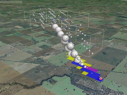
The DSS utilises two models to assess changes in landscape values – the fire regime simulator FROST and the forest landscape vegetation dynamics model LANDIS-II. Each year FROST first simulates fire in the landscape in response to particular climate, suppression, and prescribed burning inputs. LANDIS-II then simulates changes in forest structure and composition over time in response to this fire and LANDIS-II modelled harvesting (i.e. it enacts vegetation mortality, regeneration, and growth), and then feeds this vegetation information back into FROST for a successive fire year.
These yearly FROST and LANDIS-II outputs are also fed into FRAPPE (part of the FROST Family software). FRAPPE uses modelled algorithm(s) to analyse how these outputs impact different landscape values of interest. These landscape values include:
- Biodiversity (including ecological fire groups, Wet forest, ecological refuges, Leadbeater possums and Greater Gliders)
- Carbon
- Experienced High Conservation Values
- Infrastructure loss (e.g., roads, powerlines, industrial building, hospitals)
- People and House loss
- Geometric Mean of Species Abundance
- Shannon’s diversity and Fractal dimension index
- Soil Erosion Rates
- Major Water Contamination Events
- Visual aesthetics viewshed

In this way, the DSS brings together fire regimes and landscape vegetation changes to explore how changes in future climate and management practices may impact on important landscape values.
FRAPPE’s values of interest and the LANDIS-II simulation modelling brings together years of research conducted by experts in their field. These scientists are from Melbourne University’s School of Ecosystems and Forest Sciences and include Prof. Trent Penman, Dr. Julian Di Stefano, Dr. Holly Sitters, Dr. Lauren Bennett, Dr. Craig Nitschke, Ass Prof. Gary Sheridan, Dr. Sabine Kasel, Dr. Jane Cawson, Dr. Rebecca Ford, Dr. Kathryn Williams, Dr. Andrea Rawluk and Prof. Patrick Lane. The DSS project is being funded by the Department of Land Water and Planning and supported by the whole team at FLARE.