Fire management seeks to mitigate risks posed by bushfires to things deemed to be of value to society. The impetus to mitigate risk is formalised in legislation and policy in relevant fire and land management agencies across Australia. The need to formalise and justify policy choices, planning and operational decision-making on the basis of quantifiable risk mitigation benefits has been bolstered by the outcomes of recent inquiries, particularly in the aftermath of the 2019/20 fire season.
Fire management agencies require a quantitative risk-based approach to fire management. Those that have attempted to do so, rely on fire event simulators that predict the impact of the next big fire or fire(s) on human assets, such as houses and lives. Generally, these fail to consider the fire regime and as such are poor at predicting the impacts on the environment. While fire regime models have been developed around the world to test the relative importance of fire management, climate and landscape patterns on fire regimes in artificial landscapes and real landscapes. There are a number of fire regime simulators that exist however these are either localized in the fuel/fire behaviour model or are limited in the range of management strategies that can be implemented.
To address the gap, we have developed the FROST Family of tools
- FROMAGE – a data preparation program
- FROST – a fire regime simulator
- FRAPPE – a fire impact processor
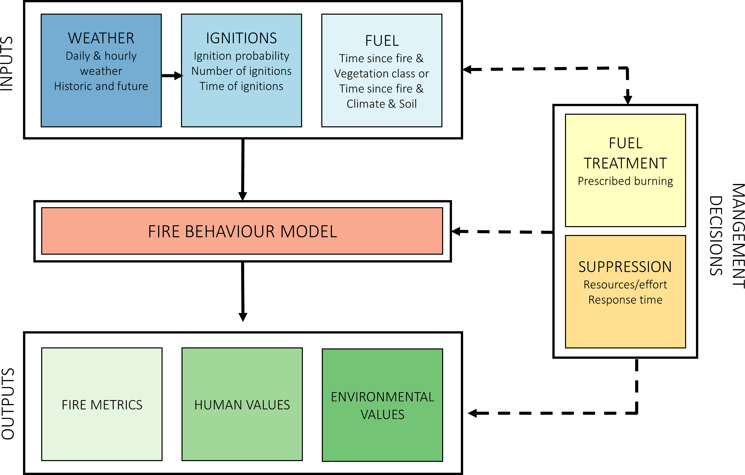
FROST (Fire Regimes and Operations Simulation Tool) a risk-based tool for assessing the impacts of fire and land management on human and environmental values across landscapes. FROST combines fire event simulation tools with Bayesian networks to represent uncertainty in the underlying processes. The model simulates fire regimes over decades to centuries. FROST is comprised of several “machines” (subsystems), depicted in the figure below.

The FRAPPE software allows us to calculate and analyse how fire (simulated by FROST) impacts different landscape values. These landscape values are represented by a number of post-processors which contain extra data and modelled algorithm(s). Each post processor utilises the FROST fire data to calculate impact on its value of interest. Values of interest include:
- Biodiversity (including ecological fire groups, Wet forest, ecological refuges, Leadbeater possums and Greater Gliders)
- Carbon
- Infrastructure loss (e.g., roads, powerlines, industrial building, hospitals)
- People and House loss
- Geometric Mean of Species Abundance
- Shannon’s diversity and Fractal dimension index
- Soil Erosion Rates
- Major Water Contamination Events

