Software:

PHOENIX Rapidfire

PHOENIX is a fire simulation model that predicts the potential progression of fire across virtual landscapes under different weather and fire suppression scenarios.

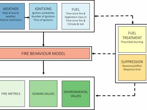
Historically, predictions of fire spread were performed manually by trained staff.  Rates of spread were computed for broad areas and maps had to be plotted by hand.  This required the synthesis of large amounts of information, incorporation of local knowledge and was very time-consuming.  This created problems when fire managers are looking for information during emergency situations. PHOENIX was developed from 2003 to rapidly replicate the manual prediction process; accounting for changes in the weather, patterns in fuel, the efforts of firefighters and the effect of varying topography

The simulation implements a fire characterisation model capturing detail such as flame height, intensity, size, ember density, spotting and convection throughout the simulation process. Such fire predictions can help identify the potential threat to homes and buildings and indicate the likely arrival times of fire.  Rapid predictions can help provide more timely warnings to communities, aid evacuation planning and help guide firefighting efforts. 

PHOENIX is widely used by management agencies in southern and eastern Australia for operational fire predictions (during an event) and for fire risk modelling (prior to the fire season).  Outputs from PHOENIX are used to support investment decisions, positioning of fire resources during a fire and evacuation decision making.  PHOENIX is now managed by Fire Predictive Services.

Projects that have applied our software

Understanding the origin and development of extreme and mega bushfires

Extreme and mega fires result in significant damage to property and infrastructure and are associated with large suppression costs. These events occur when separate fires merge. Their increase occurrence in recent seasons highlight the ...

Multiscale experimentation and simulation of wildfire spotting

Wildfires pose a significant risk to human and environmental assets around the world, especially in the Mediterranean region and Australia. Firebrands generated in wildfires are one of the most dangerous exposure mechanisms and the main cause ...

Developing detailed emission source terms for next-generation wildland fire and smoke modeling tools using improved near-field fire measurements

The primary negative impact from prescribed fires to human populations are the respiratory and visual smoke hazards when it is transported in sufficient quantities and compositions. Therefore, smoke management is paramount to prescribed ...

Our other software

FROST family

FROST family

FROST- a Fire Regimes and Operations Simulation Tool – is a risk-based fire regime simulator for assessing the impacts of fire and land management on human and environmental values across landscapes.
Prescribed Burning Atlas

Prescribed Burning Atlas

The Prescribed Burning Atlas provides a comprehensive, formal estimation of risk to key human and environmental values to support prescribed burning strategies across southern Australia.